NASA SWOT Satellite Captures Rare Tsunami Inside Greenland Fjord
In September 2023, NASA SWOT (Surface Water and Ocean Topography) satellite mission recorded a remarkable natural event in Greenland’s Dickson Fjord. This collaborative mission between NASA and France’s Centre National d’Études Spatiales (CNES) captured detailed water-level data of a tsunami contained within the fjord’s steep walls. The wave, triggered by a massive rockslide, generated seismic activity that reverberated around the globe for nine days.

Capturing Tsunami Patterns with SWOT Technology
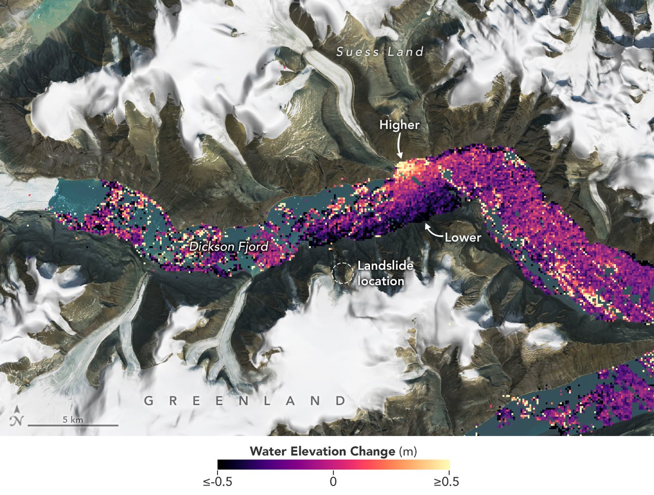
The SWOT satellite gathered water elevation data in Dickson Fjord on 17 September 2023, just a day after the rockslide unleashed the tsunami. This data was later compared with baseline measurements from early August, giving researchers a unique insight into water level changes. According to the visual data, the water levels along the fjord’s northern wall were as much as 4 feet (1.2 metres) higher than on the opposite side.
“SWOT happened to fly over just when the water had piled up high against the fjord’s northern wall,” explained Josh Willis, a sea-level researcher at NASA’s Jet Propulsion Laboratory. “Capturing the wave’s shape this way was something previously impossible before SWOT.”
This groundbreaking observation enabled scientists to measure a wave that would otherwise have gone unnoticed in such a confined setting.
Seismic Impacts and Tsunami Movement in the Fjord
Following the rockslide, researchers determined that over 880 million cubic feet (25 million cubic metres) of rock and ice crashed into Dickson Fjord, causing the tsunami. With the fjord’s steep walls reaching more than 6,000 feet (1,830 metres) and a depth of around 1,772 feet (540 metres), the fjord trapped the wave, preventing its energy from dispersing. Consequently, the tsunami oscillated within the fjord every 90 seconds for nine days, creating seismic signals detected by instruments thousands of miles away.
SWOT’s Advanced Technology and Research Potential
SWOT’s Ka-band Radar Interferometer (KaRIn) instrument, which operates from approximately 560 miles (900 kilometres) above Earth, captured the height of this confined wave with remarkable detail. As noted by SWOT program scientist Nadya Vinogradova Shiffer, this observation highlights SWOT’s potential to support disaster monitoring and preparedness efforts worldwide. Its high-resolution data enables the monitoring of changes in oceans, lakes, and rivers, making SWOT a vital tool for understanding water dynamics.
With its precise KaRIn radar, SWOT can even examine fjords with narrow, high-walled environments that are challenging for conventional altimeters to measure. “KaRIn’s resolution was sharp enough to track changes between the relatively narrow fjord walls,” said Lee-Lueng Fu, SWOT project scientist. This capability provides a valuable tool for monitoring remote and complex water systems.
About the SWOT Mission
Launched in December 2022 from Vandenberg Space Force Base in California, the SWOT mission represents an international partnership with NASA, CNES, the Canadian Space Agency (CSA), and the UK Space Agency. In addition to its KaRIn radar, SWOT includes a GPS science receiver, a laser retroreflector, and a microwave radiometer, all developed by NASA. CNES provided critical satellite components and systems, while CSA contributed to the KaRIn transmitter. Together, these advanced technologies empower SWOT to conduct comprehensive water analysis on a global scale.


